By Maria Alejandra Cardona and Curtis Williams
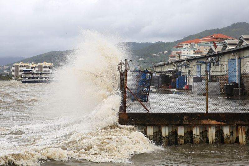
KINGSTON/PORT OF SPAIN (Reuters) -Hurricane Beryl strengthened on Monday into a “potentially catastrophic” category 5 storm as it moved across the eastern Caribbean, putting Jamaica near its path after downing power lines and flooding streets elsewhere.
Beryl brings an unusually fierce and early start to this year’s Atlantic hurricane season, with scientists saying climate change probably contributed to the rapid pace of its formation as global warming has boosted North Atlantic temperatures.
By 11:00 AST (0300 GMT) on Monday, Beryl, packing winds of up to 160 mph (257 kph), was about 840 miles (1,352 km) east-southeast of Kingston, the Jamaican capital, the U.S. National Hurricane Center (NHC) said.
The storm struck the Caribbean region earlier in the day as the earliest Category 4 storm on record, rated on the five-point Saffir-Simpson scale.
“Beryl is now a potentially catastrophic Category 5 hurricane,” the NHC said in a statement, adding that it was expected to bring life-threatening winds and a storm surge to Jamaica later this week.
The storm could dump 4 inches to 8 inches (10 cm to 20 cm) of rain on Wednesday, rising to as much as 12 inches (31 cm) in some areas, it said.
On its way, Beryl is expected to soak the island of Hispaniola on Tuesday in 2 inches to 6 inches (5 cm to 15 cm) of rain, as it moves west-northwest at nearly 22 mph (35 kph), the Miami-based hurricane center said.
Jamaica issued a hurricane warning on Monday, while tropical storm warnings were in effect for parts of the southern coasts of the Dominican Republic and Haiti.
At the Chillin’ restaurant in Kingston, waiter Welton Anderson said he felt calm despite the hurricane’s approach.
“Jamaicans wait until the last minute,” he said. “The night before or in the morning, the panic sets in. It’s because we’re used to this.”
Across other islands in the eastern Caribbean, residents had boarded up windows, stocked up on food and fuelled up cars as the storm approached.
Earlier on Monday, vehicles were seen driving through a flooded boardwalk in Bridgetown, Barbados.
The St. Vincent community of Prospect reported roofs ripped off buildings and power cuts in some areas.
In Grenada, a Reuters reporter said power was down islandwide.
Officials in Mexico began to prepare for Beryl’s arrival this week, with the federal government urging “extreme caution” on authorities and people.
Mexico is now assessing damage in its states of Oaxaca and Veracruz from heavy rain brought by former tropical storm Chris.
“What worries us is that basins are already saturated,” said Cutberto Ruiz, chief of meteorology at Oaxaca’s civil protection agency. “Then, with minimal rain … rivers will rise.”
CLIMATE CHANGE
Global warming has helped push temperatures in the North Atlantic to all-time highs, causing more surface water to evaporate, which in turn provides additional fuel for more intense hurricanes with higher wind speeds.
In May, the U.S. National Oceanic and Atmospheric Administration predicted above-normal hurricane activity in the
Atlantic this year, also pointing to unseasonably high ocean temperatures.
Scientists surveyed by Reuters see the powerful hurricane Beryl as a harbinger of an unusually active hurricane season made possible by record high temperatures in the Atlantic Ocean.
“Climate change is loading the dice for more intense hurricanes to form,” said Christopher Rozoff, an atmospheric scientist at the United States’ National Center for Atmospheric Research in Boulder, Colorado.
Beryl jumped from a Category 1 to a Category 4 storm in less than 10 hours, said Andra Garner, a meteorologist based in New Jersey.
Scientists have already predicted that events like Beryl will grow more likely with climate change, added Garner, whose research has shown rising water temperatures over the last five decades have made it more than twice as likely for weak storms to grow into major hurricanes within less than 24 hours.
On the island of Tobago, a hotel and tourism group said limited damage had been reported to hotel properties.
“The eastern side of the island got the most battering and the seas remain dangerous,” said Curtis Douglas, president of the All Tobago Fisherfolk Association.
“Fisherfolk got sufficient warning and were able to remove their boats from the water.”
(Reporting by Maria Alejandra Cardon in Kingston, Curtis Williams in Port of Spain, Robertson S. Henry in Kingstown, and Jose Cortes in Oaxaca; Writing by David Alire Garcia and Aida Pelaez-Fernandez; Additional reporting by Jake Spring in Sao Paulo and Gloria Dickie in London; Editing by Jonathan Oatis and Clarence Fernandez)