Debby will dump a tremendous amount of rain that may exceed 2 feet in some locations, triggering life-threatening flooding and immense property damage.
AccuWeather’s Bill Wadell reports Debby’s impacts in North Carolina. In Fayetteville, one abandoned vehicle was spotted submerged, and the roof of one house was damaged by a tornado in Harrells.
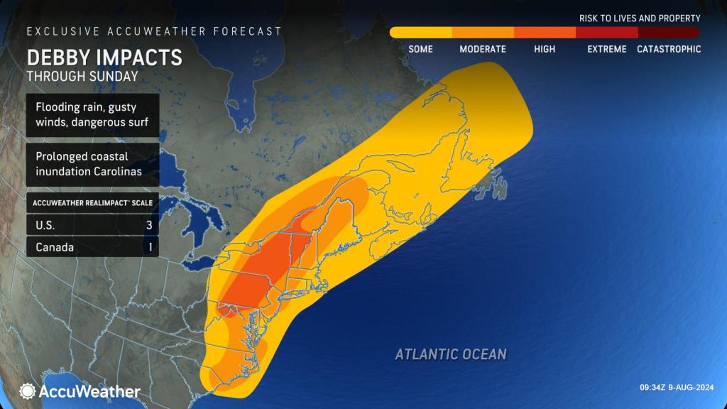
Slow-moving Debby has positioned itself to cause catastrophic flooding in the southeastern United States at midweek. Inches of rain will pour down in hours, and feet of rain will drench some communities over several days. AccuWeather meteorologists warn that life-threatening flooding will expand from coastal to inland locations and from urban areas to small streams and major rivers long after Debby made a second landfall early Thursday morning.
Debby made landfall near Bulls Bay, South Carolina, just before 2 a.m. Thursday. Maximum sustained winds at the time of landfall were 50 mph.
Flash flooding and coastal flooding have already inundated parts of Georgia and the Carolinas earlier this week, but more problems are coming to many more areas. Many rivers were on the rise from parts of Georgia and South Carolina to North Carolina on Wednesday.
Record flooding has occurred on the Canooche River in Claxton, Georgia. The location has records dating back 100 years.
River locations near the coast may experience a flooding cycle that takes weeks rather than days for some rivers over the midlands and in the upstate regions of eastern Georgia and the Carolinas.
Despite a lull in the overall coverage of rain from Debby for a time on Wednesday, there has been an explosion of rain in North Carolina and Virginia, and it is in the process of spreading much farther northward from earlier this week.
Flash flooding and storm surge are typically the most dangerous forms of flooding, while river flooding tends to be a slow-moving disaster. All are expected to occur as Debby backs slowly to the west and moves northward near the spine of the Appalachians for the rest of this week and into the weekend.
AccuWeather meteorologists continue to say that Debby will continue have dangerous, damaging and potentially devastating consequences.
According to DaSilva, Debby slammed on the brakes with its forward speed on Tuesday, as AccuWeather’s team was concerned it would do from days earlier. After moving forward at 10-15 mph, while over the Gulf this past weekend, it meandered along off the Carolina coast at a few miles per hour from Tuesday to Wednesday night.
Even as Debby’s forward speed picks up significantly, rainfall rates of 1-3 inches per hour at times in some places will add up over the hours and into Friday. The AccuWeather Local StormMax™ rainfall for Debby in the Southeastern states is 32 inches.
GET THE FREE ACCUWEATHER APP
-
Have the app? Unlock AccuWeather Alerts™ with Premium+
This will put Debby on a short list of hurricanes that brought devastating flooding to the Carolinas. Hurricane Matthew unloaded up to 20 inches of rain over several days in October 2016. Two years later, Hurricane Florence topped Matthew with up to 36 inches of rain which set rainfall records for a tropical system in the region. Both systems brought catastrophic flooding.
People living along unprotected rivers from near the Georgia border through the Carolinas and into southern Virginia should be prepared for moderate to major flooding, regardless of abnormally dry to drought conditions earlier this summer. Some of the major rivers at risk of flooding include but are not limited to the Pee Dee, Cape Fear, Rocky, Edisto and Black.
“People should be prepared to seek higher ground and to know of an evacuation route and have a plan in place,” AccuWeather Meteorologist Brandon Buckingham said.
“Water will enter rivers and other waterways that flow toward the coast. Water flowing toward the coast, coupled with the persistent onshore flow, can back up the rivers because they won’t be able to drain as they normally do, further amplifying what can already be major flooding concerns along and near the coastal areas,” explained AccuWeather Chief Meteorologist Jon Porter.
From Tuesday to Wednesday, Debby was choking on dry air, but that soon changed.
Because Debby spent a couple of days near the Gulf Stream along the Georgia and South Carolina coast into Thursday morning, it grabbed moisture from the Atlantic and is bringing it along on its northward trip now, DaSilva explained.
The faster movement for the duration will limit direct rainfall from Debby to a day or so rather than two to three days from northern Virginia to New England. Still, prior rain from non-tropical systems may have saturated the landscape in many locations. That, coupled with Debby’s additional effects, will lead to urban, small stream and river flooding from the central Appalachians to part of the St. Lawrence Valley.
The rain will not be all bad news for everyone in the Northeast. Some locations, such as western Virginia’s Shenandoah Valley, have received very little rain this summer. Any non-flooding rainfall would be welcomed, from parched lawns to agricultural and watershed concerns. But even in this rain-starved zone, too much rain will pour down in some locales and lead to small stream flooding.
The slow movement and proximity of Debby to the Atlantic in the Southeastern states into Thursday will create plenty of problems in coastal areas, ranging from constant bashing due to waves and storm surge to torrential rain, gusty winds and even a tornado and waterspout threat.
Storm surge, or water level rise above typical tide levels in coastal areas, will range from 1 to 6 feet along the Carolina coast, with a rise topping 6 feet in some areas of the North Carolina coast, including the part of the Myrtle Beach area. Water will tend to build up in the inland bays.
Wind gusts associated with Debby will be the strongest in the vicinity of spiral bands and severe thunderstorms. Gusts of hurricane force (74 mph or greater) can still occur along portions of the Carolina coast into Thursday evening.
Tropical-storm-force gusts ranging from 40-60 mph will be more common and capable of causing property damage, knocking over trees and triggering power outages. Some of the strong wind gusts will also be transported well inland over the Carolinas and eastern Virginia.
Because Debby will linger near the coast and much of the storm’s eastern flank will be exposed to the warm, moist waters of the Atlantic and large bays, some tornadoes can occur in the spiral bands from the storm.
The tornado risk will not be limited to the coastal Carolinas but will extend northward into coastal areas of the mid-Atlantic and even New England as the storm picks up forward speed.
Coastal population centers along tidal rivers will face a double whammy from storm surge flooding followed by flooding triggered by heavy rain. In some cases, as Porter warned earlier, both may occur at the same time.
“Charleston is sinking at a rate of about 0.15 of an inch per year, which may not seem like much,” AccuWeather Senior Meteorologist and Climate Change Expert Brett Anderson said. “But, combine that with rising sea levels along the East Coast, and this has greatly increased the risk of coastal flooding in low-lying places.”
Debby’s torrential rainfall caused catastrophic flooding in Charleston, South Carolina, on Aug. 6. The city streets were empty and completely underwater with only emergency responders out on the road.
Since Charleston is only about 10 feet above sea level, flooding has occurred even during high tides without a storm. Sea level rise during both tropical and non-tropical storms puts coastal population centers at greater risk.
“Since 1960, sea level along large portions of the southeastern U.S. coast has risen 5-10 inches, “Anderson explained, “The frequency of coastal flooding along the Gulf and East Coast has significantly increased over the past 60 years, with the greatest increase over the past 15 years.”
Want next-level safety, ad-free? Unlock advanced, hyperlocal severe weather alerts when you subscribe to Premium+ on the AccuWeather app. AccuWeather Alerts™ are prompted by our expert meteorologists who monitor and analyze dangerous weather risks 24/7 to keep you and your family safer.
Report a Typo