- Debby made its final landfall early Thursday and will then track through much of the East.
- The main threat will remain rainfall flooding, from the Carolinas to New England.
- However, wind gusts and isolated tornadoes are also possible through early Saturday.
Debby is no longer a tropical storm, but it will still spread flooding rain, wind gusts and isolated tornadoes through the East from the Carolinas to New England through early Saturday, after it made its final landfall in South Carolina early Thursday.
Current status: Debby’s center is accelerating north after it made its final landfall in South Carolina early Thursday morning.
While it is no longer a tropical storm, bands of heavy rain are still lashing areas from Virginia to North Carolina and parts of South Carolina. Any flash flood warnings are shown by the dark green polygons in the map below.
Debby’s outer rainbands are still spawning a few tornadoes. Any active tornado warnings are shown below in the red polygons, and any watches are depicted by the red shading.

Current Radar and Satellite
(The icon shows the current center of this system right now.)
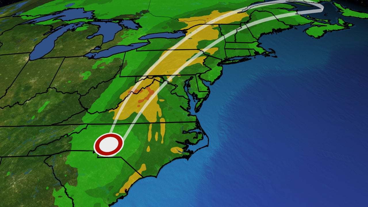
Where it’s headed: Debby won’t be a tropical system much longer, but its remnants will curl north, then northeastward through the mid-Atlantic and interior Northeast Friday into early Saturday while interacting with a pair of fronts, resulting in pockets of locally heavy rain and strong wind gusts across those regions.
Rainfall flood threat:
Southeast
Bands of locally heavy rain are likely along and to the east of Debby’s center through Thursday night in parts of the Carolinas, Virginia and West Virginia. These bands could lead to additional flash flooding and could worsen ongoing river flooding.
This threat should become more isolated by Friday, though river flooding may linger for days in the hardest hit areas.
Gusty winds in combination with increasingly saturated ground in these areas could also down trees and knock out power in spots.
Northeast
Parts of the region have been soaked multiple times this week either by rounds of severe thunderstorms, or clusters of heavy rain, such as what affected the New York City Tri-state area Tuesday.
The main threat for more widespread heavy rainfall will be from early Friday into Friday night, particularly from the Appalachians to upstate New York, in the areas shaded in red on the map below. Given wet ground from recent heavy rain in upstate New York and northern New England, any wind gusts even as modest as 30 mph from Debby’s remnant could topple some trees in spots.
About a month ago, the remnant from what was once Hurricane Beryl triggered major flash flooding from upstate New York to Vermont, northern New Hampshire and Maine, washing out roads and flooding some towns.
If you live in a low-lying flood-prone area, stay alert and follow the latest updates and warnings. Never attempt to drive through a flooded stretch of road or around barriers that signal a road closure. Over half of deaths in floods happen in vehicles, according to NOAA statistics.

How much more rain:
- Southeastern North Carolina: An additional 3 to 6 inches with locally higher amounts is possible. Storm totals including what has already fallen could be as high as 15 inches.
- Eastern South Carolina: An additional 1 to 3 inches with locally higher amounts is possible. Storm totals including what has already fallen could be as high as 20 to 25 inches.
- Central North Carolina to Virginia: Totals could be 3 to 7 inches, with locally higher amounts up to 10 inches possible.
- Maryland to upstate New York and Vermont: These areas could see 2 to 4 inches of rain, with local amounts up to 6 inches.

Rainfall Forecast
(This should be interpreted as a broad outlook of where the heaviest rain may fall. Locally heavier amounts are possible where bands of rain stall for an hour or longer. )
Isolated tornado threat: A few tornadoes could spin up in remnant Debby’s bands of rain and thunderstorms again Friday from near Chesapeake Bay to eastern New York and western New England.

Recap
Debby formed from a tropical wave the National Hurricane Center first started highlighting for possible development in the Atlantic on July 26.
Dry air kept it from developing for days as it tracked toward the northern Caribbean Islands. Eventually, it sprouted enough showers and thunderstorms, prompting the NHC to designate Tropical Depression Four at 11 p.m. EDT on Aug. 2 near Cuba.
It then strengthened into Tropical Storm Debby late on Aug. 3 in the southeast Gulf of Mexico.

Debby Track History
(The segment shown in black was when this system was Invest 97L, before becoming Tropical Depression Four. )
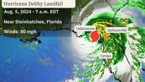
Debby intensified into a hurricane at 11 p.m. on Aug. 4 ahead of its Category 1 landfall near Steinhatchee, Florida, on the morning of Aug. 5. That was just 15 miles away from where Hurricane Idalia made landfall along Florida’s Big Bend last August.

Debby then moved inland over north Florida into southern Georgia, slowing its forward speed, before emerging back over the ocean just off the coast of South Carolina on Aug. 6.
Debby made its final landfall near Bulls Bay, South Carolina, at 2 a.m. EDT Aug. 8 with maximum sustained winds of 50 mph, then was downgraded to a tropical depression late that afternoon while centered just east of Charlotte, North Carolina.
Rainfall
Debby dumped over 10 inches of rain over many areas from western and northern Florida into eastern Georgia and the Carolinas. The peak rainfall tally was 19.67 inches near Lake City, Florida.
Flash flooding and river flooding swamped some homes, washed out roads and stranded vehicles. Among the hardest hit areas were parts of Manatee and Sarasota Counties, Florida; Live Oak, Florida; eastern Georgia including near Statesboro, and Colleton County, South Carolina, where a 20-acre pond was drained after two holes were punched in dikes surrounding the pond. Flooding was also reported in North Carolina, including Fayetteville and the Wilmington, North Carolina, metro area, where at least 3 feet of water was reported on roads north of Carolina Beach and near Leland.
The Manatee River just east of Bradenton, Florida (Rye Bridge), topped its previous record flood crest from July 21, 1962. The Canoochee River near Claxton, Georgia, topped its previous record crest that stood since New Year’s Day 1925.
Those were just two of over two dozen river gauges that rose to moderate or major flood stage from Florida to southern Virginia.
Storm Surge
Debby pushed Gulf water into the Florida coast as a tropical storm and hurricane, adding to the storm’s water impact.
This storm surge hit some of the same areas affected by Idalia almost one year ago, but likely not nearly matching the 8 to 12-foot inundation above ground of Idalia from Keaton Beach to Steinhatchee.
Cedar Key, Florida, had a storm surge of up to 5.8 feet above normal tide levels, equating to a peak inundation of about 4.65 feet above ground level as Hurricane Debby made landfall on Aug. 5.
Farther south, the combination of a new moon, high tide and Debby lead to a peak inundation at Ft. Myers, Florida, higher than Idalia and Irma, according to WINK-TV meteorlogist Matt Devitt, at just over 3 feet above ground level.
The surge and battering waves ate away at the side of the Howard Frankland Bridge over Old Tampa Bay, and chewed up a section of Harbor Drive in Venice, Florida.
Winds
Debby produced wind gusts of at least 70 mph near Chiefland (76 mph), Dania Beach (73 mph) and near Palmetto (70 mph).
Gusts over 60 mph were clocked at Cedar Key, Sarasota-Bradenton Airport (63 mph) and at Folly Beach, South Carolina (63 mph).
At the peak of the storm, over 300,000 customers were without power from Florida to the Carolinas.
Even after Debby made its final landfall, wind gusts over 30 mph and soaked ground lead to downed trees in over 70 locations in the Carolinas and southern Virginia. Numerous trees were downed in Rockingham, Stokes and Yadkin Counties, North Carolina.
Tornadoes
As with most landfalling hurricanes and tropical storms, some tornadoes were spawned across the Southeast within Debby’s rainbands.
At least seven tornadoes were spawned in the Lowcountry of South Carolina on the night of Aug. 5. That included an EF1 tornado in Edisto Beach and another EF1 twister in Moncks Corner.
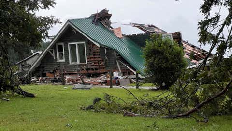
Two days later, at least one, possibly two separate tornadoes spin through eastern North Carolina, damaging homes in Sampson County and tossing debris onto a highway in Pender County, north of Wilmington. A deadly tornado after midnight on Aug. 8 near Lucama, North Carolina, collapsed a home, claiming one life.
MORE ON WEATHER.COM: Photos From Debby’s Damage

A roof collapsed on a house when a tornado hit near Lucama, N.C. as bands from Tropical Storm Debby moved through early Thursday, Aug. 8, 2024. (Travis Long/The News & Observer via AP)


