A smear of fast-moving moisture in the central Atlantic Ocean could be closing in on Florida this weekend as a tropical depression or named storm as the basin wakes up ahead of the peak of hurricane season.
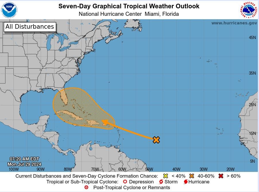
The National Hurricane Center pegged an area west of the Lesser Antilles with a 50% chance of becoming a tropical cyclone over the next seven days, noting a region from Puerto Rico through Florida and into the Gulf of Mexico as a potential nursery for a burgeoning system.
It’s been three weeks since Hurricane Beryl made landfall in Texas and the tropics have been quiet until late Friday. That’s when the NHC first identified a spot of disturbed weather that is expected to merge with a large tropical wave heading west from the coast of Africa.
Beryl’s wakeup call: Hurricane Beryl’s rapid intensification has emergency managers mulling survival timelines
Combined, the duo could slough off a storm-dampening layer of Saharan dust and become the season’s fourth tropical cyclone. The next name on the 2024 hurricane list is Debby, followed by Ernesto and Francine.
A yawning Bermuda High is expected to steer the amorphous clot of clouds toward the Greater Antilles.
A better-formed system would likely ride the western edge of the Bermuda High north, sliding east of Florida, said Fox Weather hurricane specialist Bryan Norcross. A weaker system could miss the turn, dawdling instead into the Gulf of Mexico or breaking up over the mountains of the Dominican Republic.
“The timing of all the processes for this are unknowable, so the question is what shape is it in when it gets to the Bahamas near Friday,” Norcross said. “The most important thing to remember is that forecasts for undeveloped systems are subject to large changes.”
As of Monday afternoon, the NHC had not designated the area as an invest, which is a label given to systems that forecasters have more confidence will develop. Once the invest label is awarded, data collection and processing are initiated on several government and academic websites, including those at the Naval Research Laboratory and the Cooperative Institute for Meteorological Satellite Studies at the University of Wisconsin.
Forecasters have maintained 2024 will be a busy hurricane season, despite the mostly quiet month of July. The combination of a La Niña climate pattern and exceptionally warm water temperatures led NOAA to issue its highest storm forecast on record in late May with a prediction of 17 to 25 named storms, including eight to 13 hurricanes.
Sea surface temperatures in the Caribbean and Gulf of Mexico are running 2.5 to 5.4 degrees above normal. At the same time, La Niña, which reduces storm-killing wind shear, has a 70% chance of awakening in August through October, based on a July 11 Climate Prediction Center forecast.
Hurricane season 2024: More than 1 million new Florida residents may not understand storm prep
Colorado State University increased its number of named storms for the season to 25 from the 23 it forecast June 1. It increased the number of hurricanes to 12 from its original forecast of 11.
An average hurricane season has 14 named storms and seven hurricanes.
CSU researchers noted Hurricane Beryl, which made landfall in Texas on July 8, as one reason for the increase.
“Hurricane Beryl, a deep tropical Category 5 hurricane, is also a likely harbinger of a hyperactive season,” CSU forecasters said in their report. “We anticipate a well above-average probability for major hurricane landfalls along the continental United States coastline and in the Caribbean.”
Beryl was the earliest a Cat 5 has formed. Its rapid intensification is the deepest that has occurred this time of year. It was the farthest east-forming hurricane on record for June.
Norcross said nothing is indicating the current blob being tracked by the NHC will be another Beryl or that it will rapidly intensify.
“But any time an organized system is sitting over the Bahamas and the upper-level pattern is conducive, it can’t be ruled out that something could intensify,” Norcross said. “I would put significant rapid development near South Florida in the low odds category.”
The Atlantic hurricane season begins to ramp up in early August with a peak date around Sept. 10 as ocean waters typically reach their warmest temperatures of the year and wind shear calms. The basin remains active through mid- to late October before starting to cool off in November.
➤HURRICANE GUIDE: What to do, what to buy, how to prepare for a storm
Kimberly Miller is a journalist for The Palm Beach Post, part of the USA Today Network of Florida. She covers real estate and how growth affects South Florida’s environment. Subscribe to The Dirt for a weekly real estate roundup. If you have news tips, please send them to kmiller@pbpost.com. Help support our local journalism; subscribe today.
This article originally appeared on Palm Beach Post: Hurricane center watching area that could form into tropical cyclone