
- Hurricane Beryl is located a few hundred miles east of the Caribbean.
- Beryl is likely to become a Category 3 hurricane before reaching the Windward Islands Monday.
- After that, its future in the rest of the Caribbean Sea is uncertain later this week.
- It could eventually pose a threat to Jamaica, the Cayman Islands and Mexico’s Yucatan Peninsula.
- There are two other systems we’re watching in a busy early-season pattern.
Hurricane Beryl is rapidly strengthening in the central Atlantic Ocean and is a major hurricane threat to the Windward Islands, but then faces an uncertain future in the Caribbean Sea as we also track two other systems in a busy end of June pattern.
Current status: Beryl is the first Category 1 hurricane of the season. Beryl is centered more than 500 miles east of the Windward Islands. It’s moving quickly westward over the open waters of the central Atlantic Ocean. Beryl has rapidly intensified since it became a tropical depression on Friday.
Beryl is the easternmost hurricane to form in the tropical Atlantic during the month of June, beating out a 90+ year old record.
The first hurricane of the season typically forms around August 11, using an average from 1991-2020, according to the National Hurricane Center.
Windward Islands danger: Beryl will likely continue to rapidly intensify on Sunday. The latest forecast from the National Hurricane Center shown below expects Beryl to become the season’s first Category 3 or stronger hurricane over record warm late-June water before it moves over the Windward Islands late Sunday night or Monday with flooding rain, storm surge and damaging winds.
(MORE: What The Forecast Cone Means, And Doesn’t)

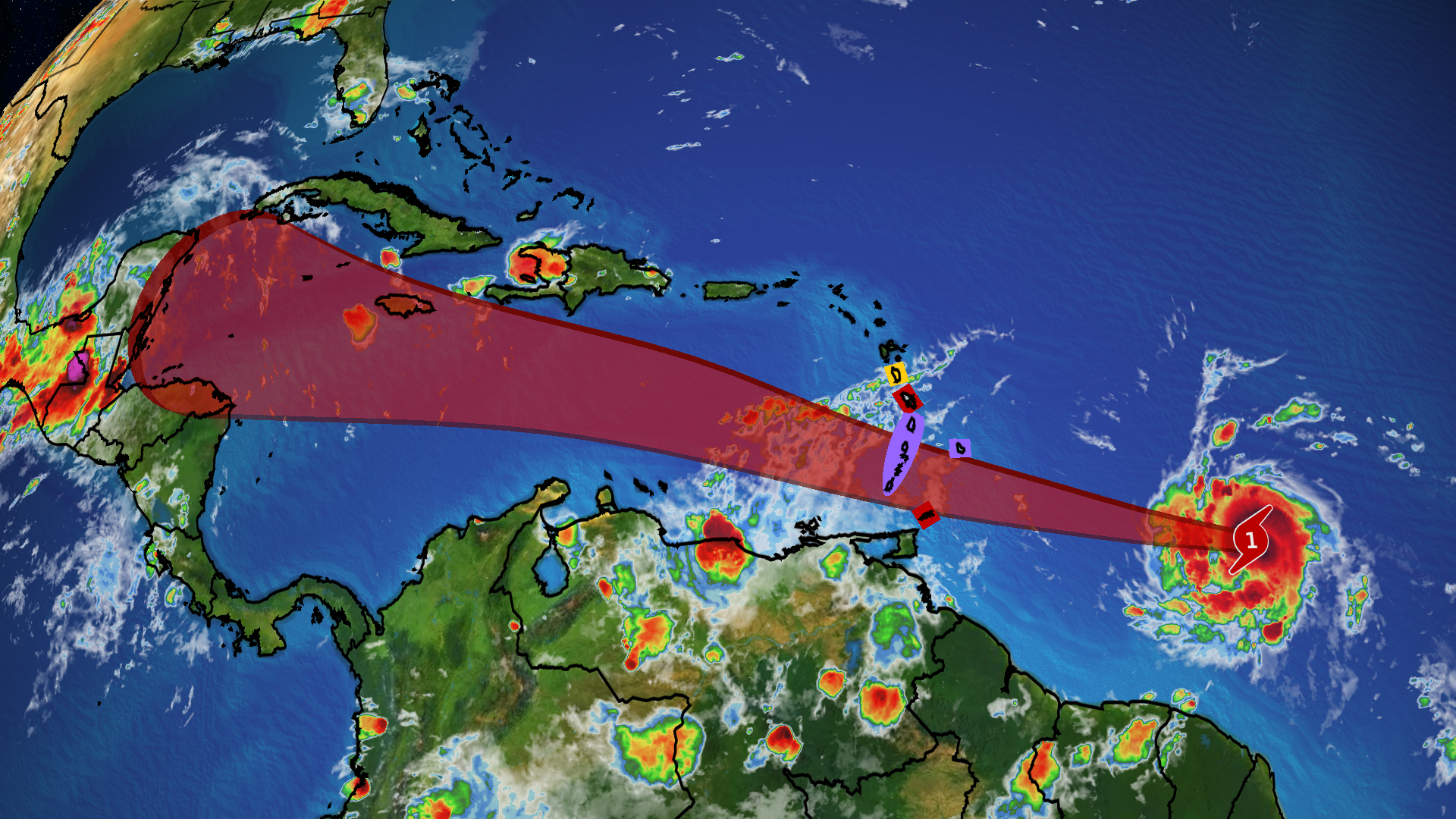
Current Status And Forecast Path
(The red-shaded area denotes the potential path of the center of the tropical cyclone. It’s important to note that impacts (particularly heavy rain, high surf, coastal flooding, winds) with any tropical cyclone usually spread beyond its forecast path.
)
Interests in the Windward islands, including Trinidad and Tobago, Barbados, Grenada, St. Lucia, St. Vincent and the Grenadines and Martinique should keep updated on the forecast of this storm and have their hurricane plans ready to go.
A narrow corridor of heavy damage is expected if Beryl’s eyewall comes ashore one or multiple of these islands as it enters the Caribbean. Flash flooding, storm surge and hurricane-force winds are expected in this corridor. These conditions could be deadly.
A hurricane warning has been issued for Barbados, St. Lucia, St. Vincent and the Grenadine Islands and for Grenada, where tropical storm conditions are expected to arrive in these islands as soon as Sunday afternoon and hurricane conditions are expected by late Sunday.
A tropical storm warning is now in effect for Martinique and Tobago.
A tropical storm watch is in effect for Dominica.
You can find a map of the latest watches and warnings here. Additional watches and warnings are likely to be issued soon for other locations.
Beryl’s uncertain Caribbean future: Beryl will move into the eastern Caribbean Sea Monday.
We then expect it to take a general west-northwest track in the Caribbean Sea through the Fourth of July week. In general, if Beryl remains strong it may track a tad farther north in the Caribbean Sea. If it is weaker, it will tend to track farther south. This uncertainty shows up in the model forecast track map below.

One reason for this uncertainty is how much wind shear Beryl will face in the Caribbean Sea. Typically this time of year, Caribbean wind shear is strong enough to weaken or completely fizzle tropical systems approaching from the east. However, some model forecasts have hinted that wind shear may be lower than usual, which could allow Beryl to survive longer than usual.

Model Forecast Wind Shear
(Areas of strong wind shear, the difference in wind speed and direction with height, are shown in purple, as forecast by the European forecast model. High wind shear is hostile to mature tropical cyclones and those trying to develop. The future system is highlighted by an arrow and circle. )
The bottom line: It’s too soon to determine exactly what kind of shape Beryl will be in when it gets to the western half of the Caribbean Sea later in the week ahead. All interests around the Caribbean Sea should monitor the forecast of Beryl closely over the next several days.
It’s also far too soon to tell if Beryl will eventually threaten any part of the U.S. Gulf Coast. Again, check back with us at weather.com for forecast updates in the coming days.
(Early Look: How A Heat Dome May Help The US)
That’s not all we’re watching: There are two other tropical disturbances in the Atlantic Basin, as depicted in the map below.
One system in the far eastern Atlantic Ocean has a high chance of development over the next week. It will remain over the open ocean until nearing the Windward Islands around the middle of the upcoming week. It could follow Hurricane Beryl within a couple of days.
The other system near Mexico, Invest 94L, has a medium chance of developing once it emerges into the Bay of Campeche or southwest Gulf of Mexico this weekend, before it glides into eastern Mexico in the early part of the week.
(MORE: What Is An Invest?)

Heavy rain threat: Regardless of development, Invest 94L could dump locally heavy rainfall from parts of Central America to southern and eastern Mexico. Local flash flooding and landslides are possible, especially in areas of higher terrain.
Some increased swells, rip currents and coastal flooding are also possible along parts of the Mexican and Texas Gulf Coast Sunday into at least early Monday.
(Further beef up your forecast with our detailed, hour-by-hour breakdown for the next 8 days – only available on our Premium Pro experience.)

Rainfall Outlook
(This should be interpreted as a broad outlook of where the heaviest rain may fall and may shift based on the forecast path of the tropical system. Higher amounts may occur where bands of rain stall over a period of a few hours. )
Tropical Atlantic development has happened in June as recently as last year. As senior meteorologist Chris Dolce discussed, tropical development east of the Lesser Antilles where Beryl is located in June is unusual, but has happened in recent years, including 2023.
Last June, tropical storms Bret, then Cindy, each developed well east of the Lesser Antilles in less than a week’s time. It was the first time on record two tropical storms formed east of the Lesser Antilles (east of the Caribbean islands) during the month.
Bonnie first became a tropical storm in late June 2022 east of Trinidad and Tobago before it traversed the rest of the southern Caribbean Sea, then later became an eastern Pacific hurricane.
At the end of June 2021, what would later become Hurricane Elsa first became a tropical storm in almost the same location as 2022’s Bonnie.

Check back with us at weather.com for updates to this forecast as the details become clearer in the days ahead.
MORE ON WEATHER.COM
- Why Hurricane Season’s More Active Phase May Arrive Earlier
- How To Prepare For Hurricane Season
- What’s Been Deadliest In US Hurricanes, Tropical Storms Lately May Surprise You